
I sated some of my mountain lust during the third pandemic lockdown by studying the recently published guidebook Snowdonia: Mountain Walks and Scrambles, which I had been given for Christmas. I looked longingly at the many colour photos of Welsh mountains and the routes up them that it describes. The guidebook gave me a chance to remember fondly days I’d spent in those mountains, and to dream of walks that I had not yet done. One route caught my attention and imagination more than the others – the North-East Ridge of Y Garn. The guidebook gave it three stars (out of three) and described it as “One of the finest walking ridges in Snowdonia.” This route somehow had passed me by even though I had literally passed by this ridge many times. I wrote the name and page number of the entry for this route on a scrap of paper, along with the details of the other routes that interested me. I then put this note between the pages of the guidebook for use when a global pandemic wasn’t preventing me from getting to the mountains.
For a variety of reasons, it was a lot longer than I intended before I put this guidebook to use. A few years later and several weeks ago, I finally set out from the Ogwen Cottage car park for the North-East Ridge of Y Garn.

The route was simple. I just followed the substantial, stone-paved path to the shore of Llyn Idwal and then took a right to the start of the ridge. I felt happy to be back among tall rocky mountains as I crossed the bridge over the stream that flows from Llyn Idwal. I felt even happier as the dramatic Cwm Idwal came more and more into view. I spent some time by the lake just taking in the sights of the corrie before heading for the ridge.
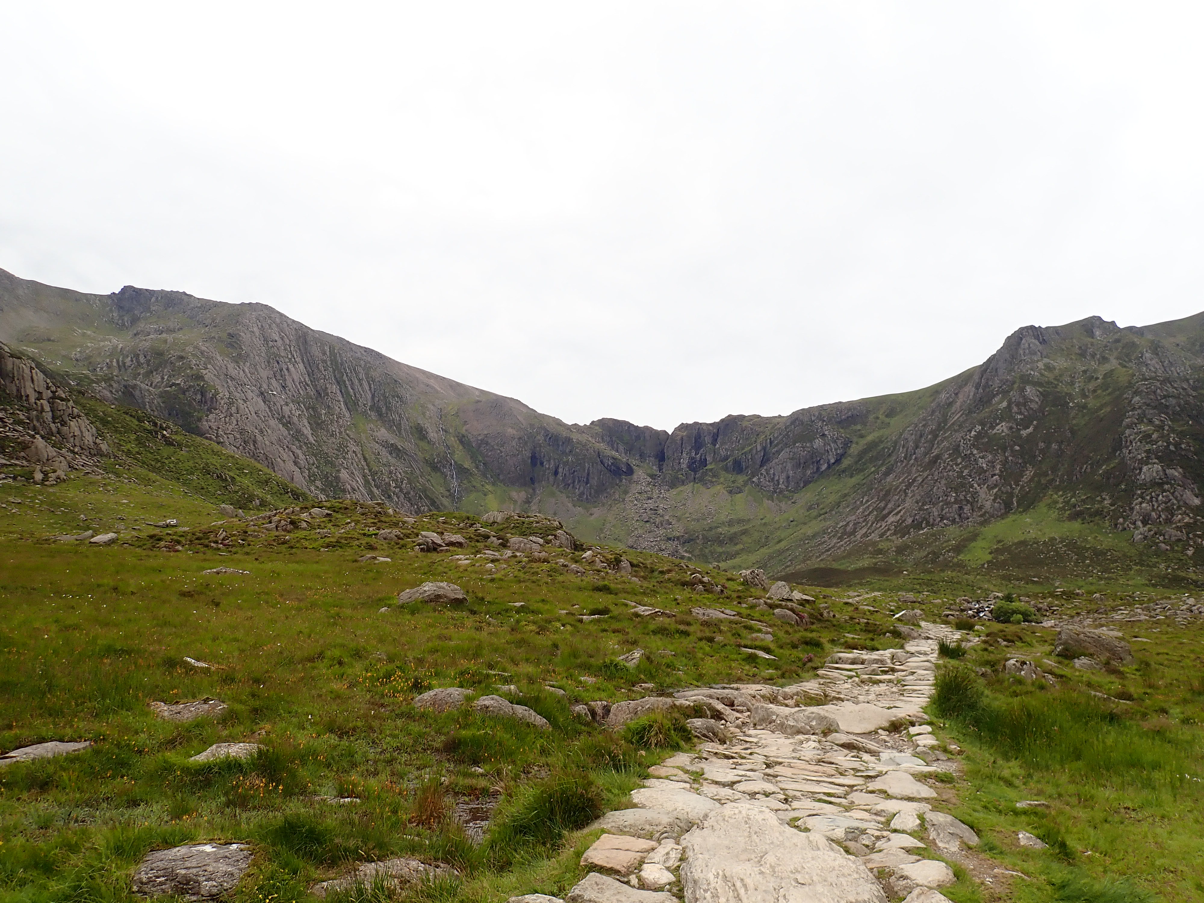

I could see almost all the route up the north-east ridge from Llyn Idwal. It meandered up through rocks and heather before reaching Cym Clyd, and then turned to follow close to the skyline until the top of Y Garn. I kept glancing at this route, thinking about how it would be, as I followed the path around the edge of the lake.

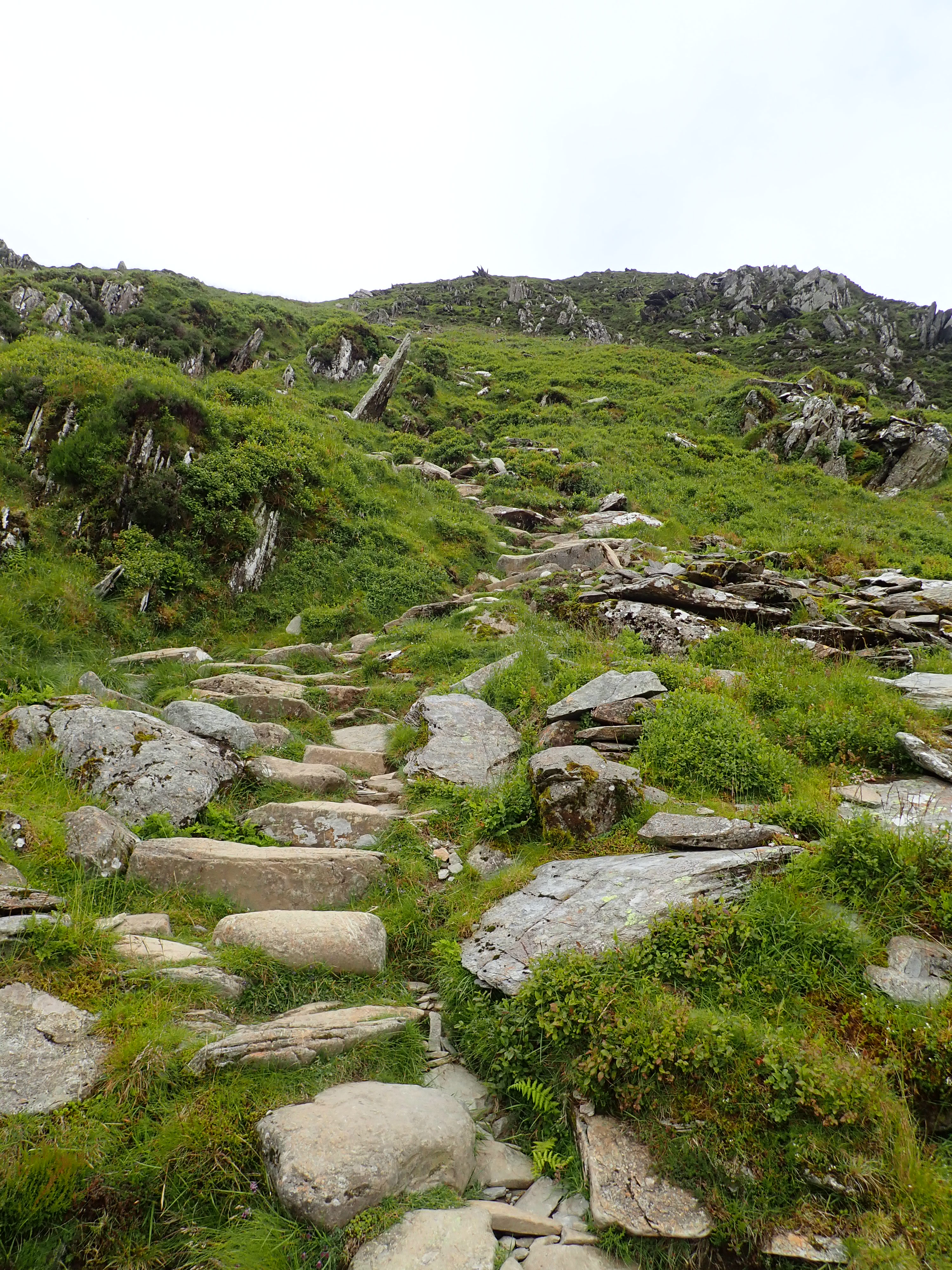
The path started out on a relatively gentle gradient after it broke away from the lake to go up the grassy slope of the ridge. I passed occasional, pretty clumps of purple-flowering heather and wondered if it was a bit early in the year to see them in bloom. I also passed a bright orange tent pitched on the crest of the ridge. A little later I’d pass another tent sitting on the ridgeline, pass a father and young daughter carrying camping equipment down the path, and see several tents pitched by the small lakes in Cym Clyd. While I’d read about wild camping becoming more popular during the pandemic, I was still surprised by how much camping I saw on this ridge.

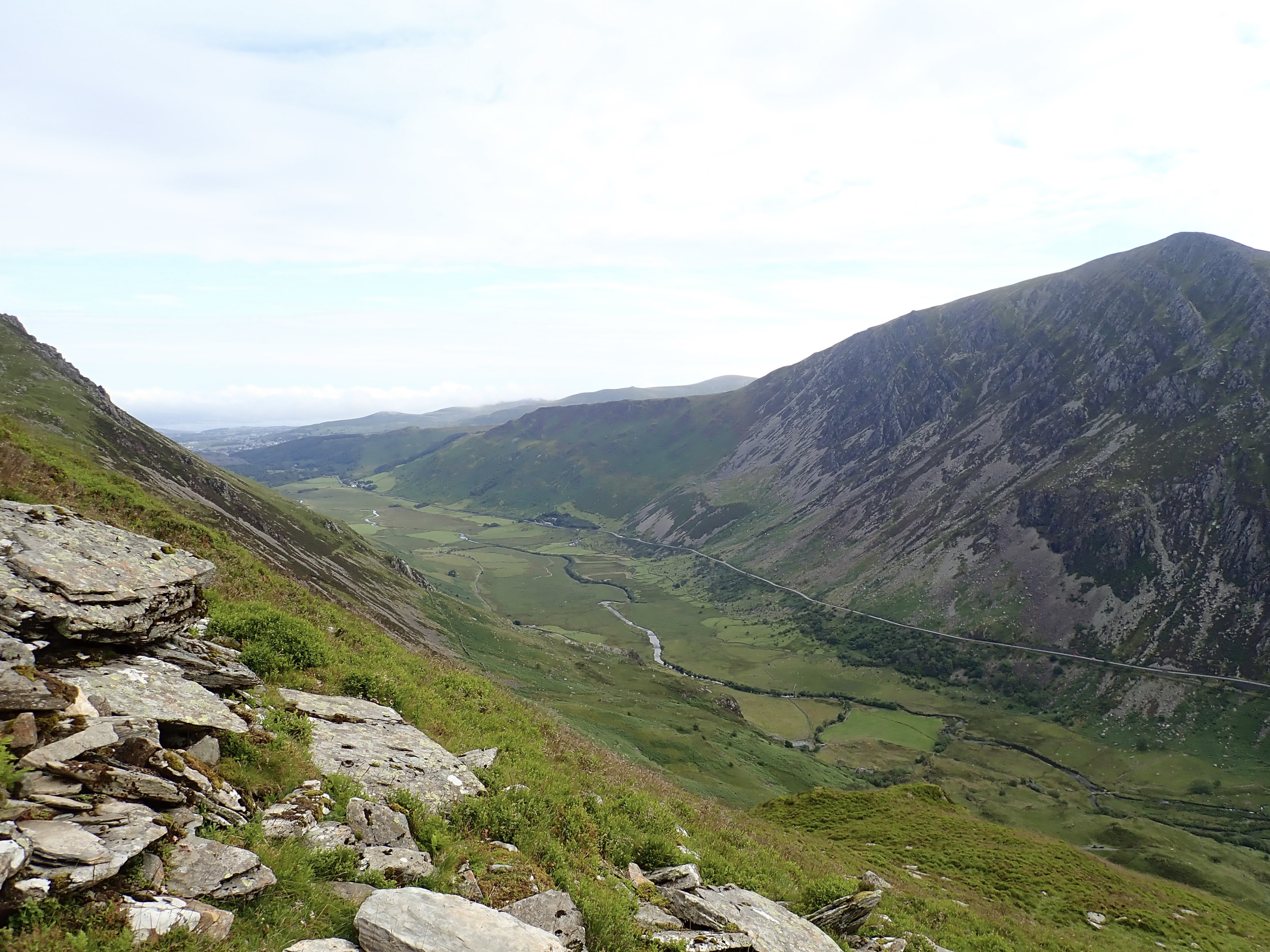
Not long after I had passed the orange tent, the path steepened, and I slowed to the steady pace I needed to get myself to the top. This section of the ridge would have been an unremitting trudge up rough rock steps if there had been low cloud, but I had amazing views down either side of the ridge and behind me that I regularly turned to admire. These views became more superlative as I got higher. I could see into Cwm Idwal, with the Glyders looming behind. The full sweep of the valley as it curved around the pyramid of Pen yr Ole Wen became visible. I could look down the Ogwen Valley to Llyn Ogwen and the prominent fin of Tryfan. In the other direction, the gentle valley of Nant Ffrancon swept into the distance and towards the blue of the Menai Strait. It felt hard to believe that there could be a better viewpoint in North Wales than the North-East ridge of Y Garn.

Those views helped to keep me going on the climb, but it was still a relief to arrive at the lip of Cwm Clyd. This grassy corrie is scooped out of Y Garn, with the summit sitting above it and the north-east Ridge curving around one side. Cwm Clyd was a peaceful, attractive place to take a break and to soak up the view.


The path out of the cwm was much less steep as it headed back onto the grass-covered ridge. There were great views down the steep, north side of the ridge into Cwm-coch and, as I got higher, across to Y Garn’s neighbouring peak Foel-goch. The views down the valleys and across the Glyders became more expansive and awe-inspiring as I slowly climbed.

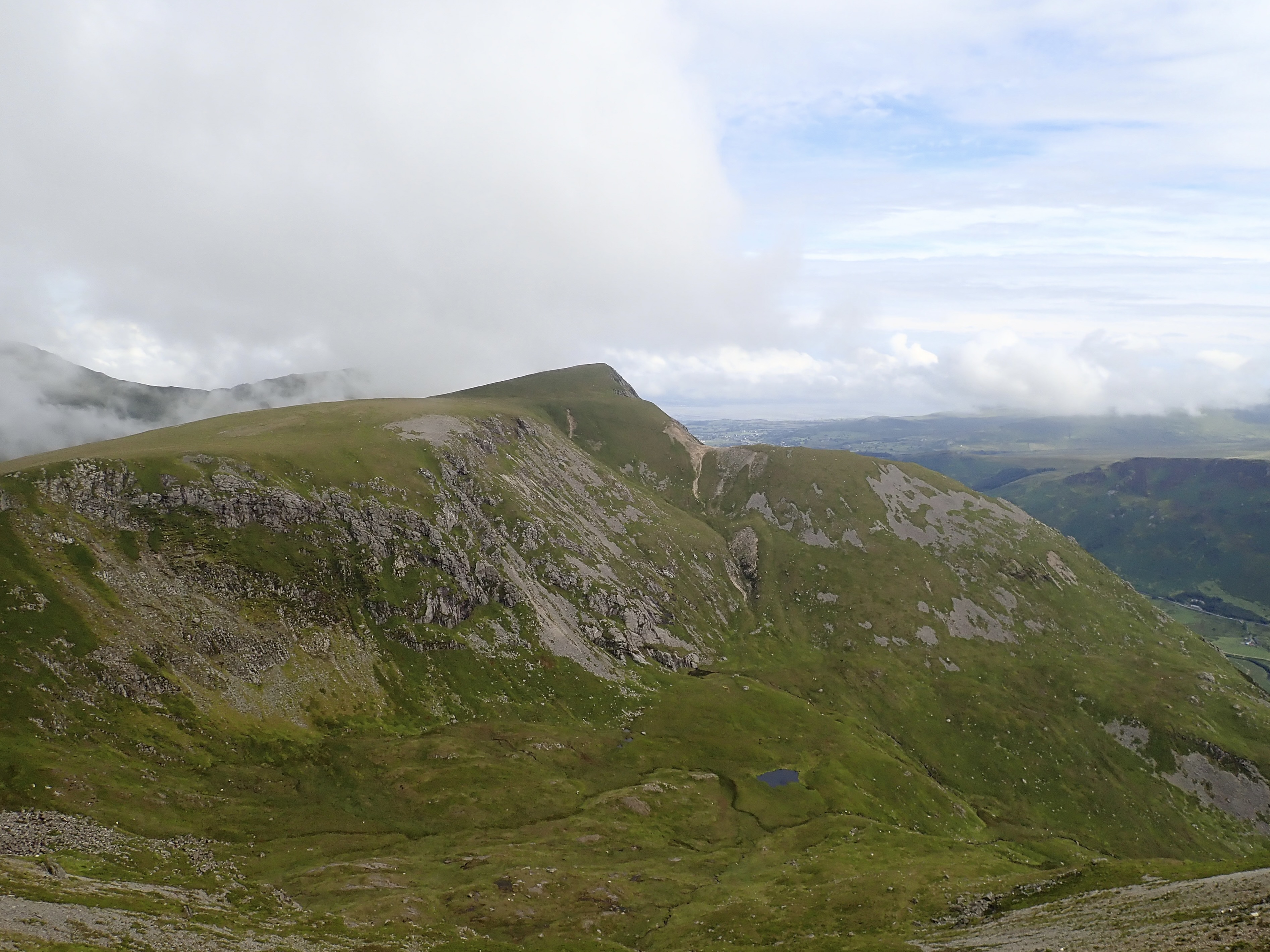

The broad summit ridge was a marked change from the ridge I’d just come up, and it felt like a gentle stroll up to the rocky summit of Y Garn. Pleased and content, I had an early lunch sitting on a rock by the summit shelter, and enjoyed sublime views back down the north-east ridge, across the valleys and cwms, and over the mountains of the Glyders and Carneddau.


After a few groups had come and gone from the summit, and I’d looked at my watch, I decided I should probably move on. I headed down the wide, sweeping south-easterly slope of Y Garn, enjoying the views of Glyder Fawr in front of me when I wasn’t looking where to put my feet.

The slope became more gradual, and the path better built, until I reached Llyn y Cwn. This pretty little lake is nestled below the craggy slopes of Glyder Fawr. I skirted the lake to follow a solid path past interesting, rough rocks to the stone cleft that leads down to the Devil’s Kitchen.


This path past the dark cut of the Devil’s Kitchen and down to Llyn Idwal has a thigh-burningly large number of substantial rock steps and the occasional, small scrambling section. This was the best visibility I’d ever descended this path in, and the views from this path to Llyn Ogwen, Pen yr Ole Wen, and the Idwal Slabs were stunning.


I took the path around the west side of the llyn and stopped at the rocky beach on its north shore to have the remainder of my coffee. I’d thought this would be a good point to admire the view again before I headed for my car, but the rain started almost as soon as I pulled my flask from my rucksack. As the clouds and the rain came down, I briskly retraced my steps to Ogwen Cottage and felt pleased with my fantastic day in the mountains.

Further information
The book Snowdonia: Mountain Walks and Scrambles is by Mark Reeves and is published by Rockfax.

Enjoyable read Robin. It is a lovely walk up Y Garn with great views. And it’s not many mountains that you can see your car from the top of the mountain!
Thanks Jim.
That’s true. You’ve got me trying to think of other ones. There must be more.
We stopped in a cottage in St John’s in the vale once and my wife, who was in the cottage was able to video me standing on the top of Blencathra!
That’s impressive. Nice to have the video as well as a more unusual memento.
That reminded me that my wife managed to see me waving to her from the top of the Rotstock when she was on the Eiger Trail below. She took a photo of me waving, but I had to magnify it quite a bit to make me even slightly visible (I included the photo in a blog post about the Rotstock Via Ferrata – https://thesevereclimber.com/2013/07/22/rotstock-via-ferrata/). However, I think the distance was probably less than between St John’s in the Vale and the top of Blencathra.
I’ve just read your post! Funnily enough we were in Grindelwald about four weeks ago and went up to Jungfraujoch! And it was great to see the Eiger up close, if not quite as close as you did.
I’m envious. The views are stunning. I hope you managed to get some good walks in.
Got a few in, one of which I’ve just posted! And managed to finish off a bit of the TMB that I had to miss last year because of the weather
Sounds good. I’ll check out the post.
I can’t remember which ridge is which as I can’t remember which way Y Garn faces – but is that the ridge up to the right of Llyn Clyd then? I thought you were going for the one up to the left of it, which I think is a very hard scramble – probably Grade 2 or 3, when I saw the title. I like that walking ridge up (the one you did here) and also there was a route up from Llyn Clyd which went up the back of the cwm we did once and I think that was quite nice too.
Yes. If you’re standing by Llyn Idwal, looking up at Y Garn, the ridge on your right, and running to the right of Cwm Clyd, is the North-East Ridge. The ridge to your left, and running to the left of Cwm Clyde, is the East Ridge. The East Ridge is a scramble. I think a fairly common route is to do the scramble up the East Ridge and then descend by the North-East Ridge.
I watched a YouTube of the East Ridge Scramble and it looked fearsome in places!
Yeah. I think I’ll stick with the NE Ridge – all the views, none of the fear.
I didn’t think you’d find it fearsome, I thought it looked like it would be your sort of thing.
I prefer grade 1 scrambles. Once it gets harder than that, I prefer to be roped (which, of course, you can be).
I’m exactly the same. I love a nice, mild scramble, preferably with escape routes one side or the other. But, when it gets serious, I want a rope please…